Helvellyn
Five of the top ten favourite walks in Britain are in the Lake District, with Helvellyn voted the best in a poll of 8000 walkers according to ITV’s recent programme “Britains Favourite Walks”, featuring Julia Bradbury
The route via Keppel Cove was featured, but there are many ways to climb Helvellyn, explore the surrounding area and enjoy the most fabulous views
The routes range from sharp, steep, climbs on the west side, to short airy ridges on the east and fantastic long ridges from the north-east, which we think are the most interesting and rewarding, returning for a well deserved pint in The Royal at Dockray or the Travellers Rest in Glenridding
We have selected our Top Ten routes, with some additional variations, but there are still further options, demonstrating what a fantastic place the Helvellyn range is for walking – not just Julia’s route to the top!
For those with even more energy, our first route forms the basis of much of the second section of the famous Bob Graham round, illustrating that the Helvellyn range is also a brilliant place for Fell Running, with the best long ridge run in Britain too
Images courtesy Pete Tasker - please visit Pete's website or Gallery in Keswick
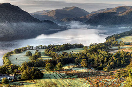
Castlerigg with Helvellyn Range in the background

Routes from the North East
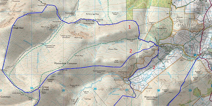
1. High Brow – Clough Head – The Dodds – Helvellyn (9.8 miles, 3497 feet ascent)
Our first route begins with a stroll along the coach road before climbing to Clough Head via White Pike. One of the best ridge walks in Britain, five miles of undulating, well marked tracks take you to the summit via Great, Watsons and Stybarrow Dodds and then onto Raise and Whiteside.
This will require a full days walking including the return, perhaps via Glencoyne as a gentle return at the end of a strenuous day.
2. High Brow – Great Dodd – Sticks Pass - Raise – Helvellyn (7.1 Miles, 3014 feet ascent)
High Brow – Hart Side – Sticks Pass – Raise – Helvellyn (6.2 miles, 2651 feet ascent)
Our next two routes join together at Sticks Pass, proving perhaps a more manageable day with the former still providing a great long ridge.
Hart Side is a lesser known alternative to the crowds ascending via Glenridding and Patterdale, but with most of the ascent early and gentle it is a great route to the summit.
On the way you will visit Birkett Fell, overlooking Ullswater, named after Norman, Lord Birkett, credited with saving the most beautiful lake in England from becoming a reservoir.
A gentle path takes you via White Stones to Sticks Pass or a slightly higher level option via Stybarrow Dodd
3. Dockray – Round How - Sticks Pass – Raise – Helvellyn (6.1 miles, 2552 feet ascent)
Glencoyne - Sticks Pass – Raise – Helvellyn (5.4 miles, 3133 feet ascent)
These options are perhaps a little more gradual ascent, combined with a quieter approach, at least until Sticks Pass (!) , with great views of Ullswater throughout
Routes from the East
4. Glenridding – Greenside – Keppel Cove – Whiteside – Helvellyn (4.5 miles, 2616 feet ascent)
The featured route, initially ascending with paths either side of Glenridding Beck and then onto Keppel Cove, before ascending steeply via a Zip-Zag path to the East of Red Screes and up onto Whiteside before attaining the summit
Glenridding
5. Glenridding – Birkhouse Moor - Catstye Cam – Swirral Edge - Helvellyn (4.5 miles, 2616 feet ascent)
Helvellyn from Birkhouse Moor

The path traverses the slopes of Birkhouse Moor, ascending from Rattlebeck Bridge in Glenridding to the Hole in The Wall. Proceeding to Red Tarn, you then turn back north east and ascend Catstye Cam. Proceeding along the short but impressive Swirral Edge provides a fantastic route to the summit.
6. Patterdale – Hole in the Wall – Striding Edge - Helvellyn (4.4 miles, 2829 feet ascent)
Embarking at Grisedale Bridge, the well worn path slants west across the flanks of Birkhouse Moor to the Hole in the Wall stile.
Hole in the Wall

Great views into Grisedale and across to St Sunday Crag. The path crests at High Spying How before Striding Edge
Helvellyn Striding Edge

7. Patterdale – Grisedale - Dollywagon Pike - Helvellyn (6.8 miles, 2905 feet ascent)
The route up Grisedale to the Tarn provides a gentle steady ascent to 2000 feet over nearly five miles, passing the Climbers Bothy of Ruthwaite Lodge after four miles.
The path up from the Tarn ascends Dollywagon and Nethermost Pikes before summiting.
8. Patterdale- St Sunday Crag – Fairfield – Grisedale - Helvellyn (7.6 miles, 4625 feet ascent)
St Sunday Crag

The route via St Sunday Crag provides a greater challenge, but is well rewarded, with the route across Deepdale Hause particularly memorable, before ascending Fairfield. The mile to Grisedale Tarn was memorably referred to by one of our party as a pointless down, with a thousand foot drop. After the mile and a quarter ascent to Helvellyn summit, the gap to Fairfield and St Sunday Crag is a rewarding view for your efforts!
Routes from the West
9. Wythburn – Nethermost Pike - Helvellyn (2.1 miles, 2343 feet ascent)
The path up Birk Side is intermittently pitched and fairly steep, joining the path for Nethermost Pike at Swallow Scarth but is a rapid way of reaching the summit.
10. Swirls – Browncove – Lower Man - Helvellyn (2.0 miles, 2377 feet ascent)
Thirlspot – Brown Crag – Lower Man - Helvellyn (3.2 miles, 2576 feet ascent)
The Swirls path is one of the most used in the Lakes and is fairly straightforward as a result, having been substantially rebuilt in recent years.
The Thirlspot path via Brown Crag was originally extensively used to access Helvellyn via horseback from the Kings Head but has in places become indistinguishable, but is all the quieter for all that and offers an alternative.
The maps below illustrate the routes together


Conclusion
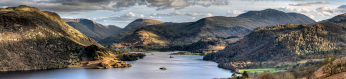
Helvellyn is deservedly Britains favourite walk in our view, if for no other reason than the great variety of routes to get there – and come back! The views on the way and from the top are stunning, particularly towards Ullswater, as illustrated by the photographs by Pete Tasker, accompanying this article
In winter, fell top weather assessors walk to the top every day to report on conditions and there is a ski lift on Raise, both for good reason, as winter conditions can be challenging, but with the right equipment and experience, great fun.
To learn new skills, particularly in winter conditions, you may wish to accompany experienced guides. For walking we would suggest Mountain Days and for running, Charlie Sproson of Mountain Run, who lives in Glenridding
To enjoy all the walking and adventures the area has to offer – and to try all ten routes in a week to judge for yourself which really is the best route up (and down!) Helvellyn.
Enjoy the walking (or running!), relax afterwards at High Brow and treat yourself to a well earned dinner in one of the great local restaurants around the Ullswater area